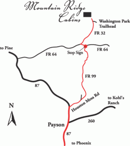
Directions from Phoenix, Arizona
4216 Mountain Ridge Rd., Payson, AZ 85541. This is a relatively new address and your GPS may or may not work. If relying on GPS, PLEASE make sure your GPS states that it is Payson, and not some other city.
Coordinates: N34 degrees 25′ 40″ W111 degrees 16′ 11″
(NOTE: If you use the coordinates, your GPS may tell you to take a right at the stop sign in Whispering Pines. DO NOT DO THIS! Instead, take a left onto 64, THEN a right on Service Road 32 after .6 miles.)
PLEASE PRINT OUT THESE DIRECTIONS. YOU WILL LOSE SERVICE SOME TIME DURING THE LAST 30 MINUTES OF YOUR TRIP: Travel north on Beeline Highway (AZ 87) to the city of Payson, Arizona. Payson is your last gas stop, as well as the last stop for reasonably priced groceries. The largest intersection in Payson is at the junction of Route 260 and Highway 87; at that intersection set your odometer to 0. The odometer settings are important, as the roads are not marked very well. Stay on 87 through Payson.
(NOTE: The following part of the directions are VERY specific, as we’ve had a number of people get lost while traveling to Mountain Ridge Cabins. You will only take 4 turns starting with the first from the Beeline: right onto Houston Mesa Road; left onto Control Road 64; right onto Control Road 32, and then a left onto our private road.)
After the second roundabout, turn right (east) onto Houston Mesa Road. This road intersects 87 just before the Highway narrows from four lanes to two; there is a turning lane. Reset your odometer to 0. Once you turn onto Houston Mesa Road, it is also called Rim Road 199. You will be on this road for a total of 10.3 miles. (Stay right at the V in the road and do not veer left toward Mesa del Caballo.) Pass the Houston Mesa General Store (at 1.9 miles).
You will cross over the East Verde River three times. After the third crossing, you will come to the town of Whispering Pines and the only stop sign in town (10.3 miles after you turned off Highway 87). Reset your odometer to 0. Turn left at the stop sign onto Service Road 64, a graded gravel road.
Six-tenths (.6) of a mile past the stop sign, there will be a sign listing Washington Park Trailhead. Turn right onto Service Road 32. Once you turn, there is a small sign on your right, 32. Re-set your odometer to 0. At 2.4 miles, there is a “V” intersection; veer left. At 3 miles, 32 veers left again.
Continue on Service Road 32 and pass the turn-off for Washington Park Trailhead. One-half mile (.5) past the Trailhead turnoff sign, Service Road 32 ends. A sign in front of you reads “Mountain Ridge Cabins”. Turn left onto the small winding road. This is a one-lane road with two-way traffic, so please drive slowly and carefully. Stay to the right where road divides to go over concrete crossing.
Our gate swings out towards you, so leave enough room to open it. Please ring the bell and our managers will meet you and escort you to your cabin.

